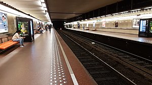
Madou metro station
 Madou metro station | |||||||||||||||
| General information | |||||||||||||||
| Location | Place Madou / Madouplein 1210 Saint-Josse-ten-Noode, Brussels-Capital Region, Belgium | ||||||||||||||
| Coordinates | 50°50′59″N 4°22′08″E / 50.84972°N 4.36889°E | ||||||||||||||
| Owned by | STIB/MIVB | ||||||||||||||
| Platforms | 2 | ||||||||||||||
| Tracks | 2 | ||||||||||||||
| Construction | |||||||||||||||
| Structure type | Underground | ||||||||||||||
| History | |||||||||||||||
| Opened | 20 December 1970 (premetro) 2 October 1988 (metro) | ||||||||||||||
| Services | |||||||||||||||
| |||||||||||||||
Madou is a Brussels Metro station on the northern segment of lines 2 and 6. It is located under the Small Ring (Brussels' inner ring road) at the Place Madou/Madouplein, next to Madou Plaza Tower, in the municipality of the Saint-Josse-ten-Noode, north of the City of Brussels, Belgium. The station takes its name from that aboveground square, itself named after the painter and lithographer Jean-Baptiste Madou.
The station opened on 20 December 1970 as a premetro (underground tram) station on the tram line between Madou and Porte de Namur/Naamsepoort. It became a heavy metro station, serving line 2, when this line was converted on 2 October 1988. Then, following the reorganisation of the Brussels Metro on 4 April 2009, it now lies on the joint section of lines 2 and 6.[1][2]
See also
[edit]References
[edit]- ^ "Line 2 direction SIMONIS - stib-mivb.be". www.stib-mivb.be. Retrieved 6 August 2024.
- ^ "Line 6 direction ROI BAUDOUIN - stib-mivb.be". www.stib-mivb.be. Retrieved 6 August 2024.
External links
[edit] Media related to Madou metro station at Wikimedia Commons
- STIB/MIVB official website
